- 1 January, 2026
- Comments Off on The sea of wood in Geudumbak, Langkahan District, North Aceh
Ecological Disaster: Massive Floods and Landslides in Aceh Carry Mud and Forest Wood
The massive floods and landslides in Aceh that occurred at the end of November 2025 were triggered by extreme rainfall following tropical cyclone Senyar's landfall in Aceh, Sumatra. Thousands of landslides occurred in the hills and mountains upstream of the watershed. Soil and forest trees slid downstream and were carried by the current. The severity of this disaster is also increasingly suspected to be human-caused. Deforestation and degradation in the Aceh watershed have been occurring for a long time.
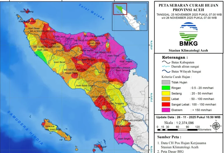
The floods and landslides that occurred in Aceh at the end of November 2025 were extraordinary events. Heavy, even extreme rainfall continued for days in Aceh, especially in the eastern part of the country. The heavy rains were triggered by the formation of a tropical cyclone, designated 95B, in the Strait of Malacca. According to the Meteorology, Climatology, and Geophysics Agency (BMKG), this tropical cyclone formed on November 21, 2025. Based on their monitoring on November 22, 2025, the cyclone had the potential to weaken and move east-southeast. The Aceh BMKG also issued a cyclone warning in the "Aceh Climatology Info" WhatsApp group on November 23, 2025.
Rain and flooding are common in Aceh, and on those days, it had already occurred in Bahagia City, South Aceh. However, on November 25, 2025, several group members reported that the rain in their area had become increasingly alarming, continuing for over 24 hours and causing flooding and landslides. This occurred in North Aceh, Central Aceh, and Langsa. As the night wore on, the weather became increasingly tense due to the continuous rain.
We can monitor the movement of Cyclone Senyar through the zoom.earth website. Initially, the cyclone was predicted to move clockwise, as is typical for cyclones north of the equator. After moving west from the Strait of Malacca towards Langsa, it was initially predicted to move north, towards Lhokseumawe or Banda Aceh. However, an anomaly occurred; the cyclone moved south, counterclockwise, towards Medan, and then east towards Malaysia.
Early that morning, photos and videos of massive flooding inundating homes from North Aceh and news from Pidie Jaya were posted in the group. In the early hours of November 26, 2025, the Joint Typhoon Warning Center (JTWC), which can be viewed through zoom.earth, upgraded the status of the cyclone from tropical cyclone 95B to tropical cyclone 04B. The BMKG (Meteorology, Climatology, and Geophysics Agency) also released the news that the cyclone had evolved into tropical cyclone Senyar. Many residential areas were affected by devastating flooding, submerging homes. Many national roads and other infrastructure were impassable due to flooding. Hundreds of bridges were cut off and damaged. The cyclone also knocked down power towers and disrupted internet access in Aceh, leaving parts of Aceh isolated by both transportation and communications.
On November 27, 2025, a video of the Regent of Central Aceh reporting the dire conditions in the interior of Central Aceh reached the region. Information was extremely difficult to obtain due to the lack of electricity and internet. In some parts of Aceh, such as East Aceh, Langsa, and Aceh Tamiang, no news was received. On November 29, 2025, the European Union's Copernicus satellite finally released its Sentinel 2A satellite imagery, revealing the extent of the flooding in Aceh. Using the same imagery, massive landslides were clearly visible on the ridges and mountains in the interior of Aceh's forests, as if torn apart, collapsing into the headwaters of the Aceh River. Various reports on the impact of the flooding in Aceh, as well as in North Sumatra and West Sumatra, have appeared in national and online news media.
There are conflicting opinions about the cause of the severe impact of this flood. This was no ordinary flood, which only brought water. Instead, it also brought with it a large amount of mud and wood. Previously, news reports had only reported piles of wood in North Sumatra. However, the piles of wood in Aceh caused by the floods were also found in Aceh Tamiang and North Aceh.
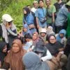
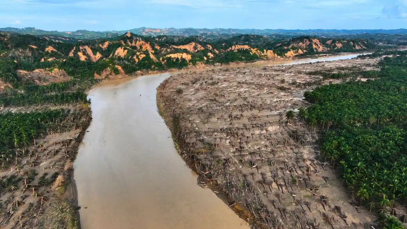
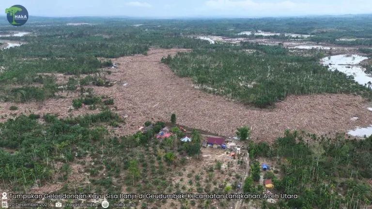
On December 20, 2025, the HAkA Foundation had the opportunity to conduct direct field monitoring using drones. We observed a sea of wood piled up in Geudumbak, Langkahan District, North Aceh. A sea of logs, both large and small, stretched across the river, residential areas, and residents' gardens. Several excavators were already working to clear the piles. Several HAkA team members who entered and climbed into the sea of wood appeared minuscule compared to the surrounding area.
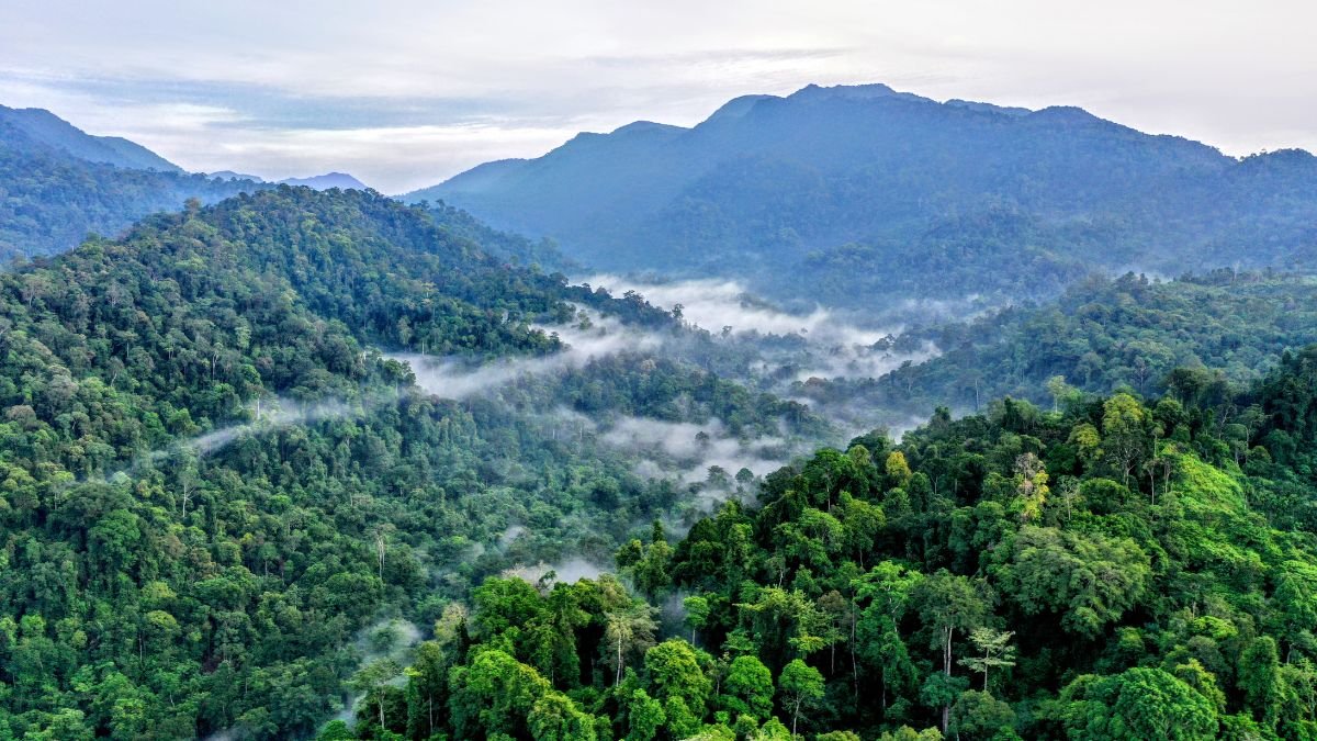
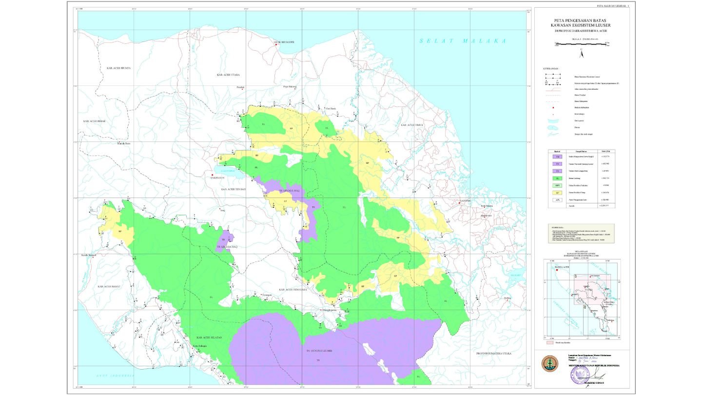
This geudumbak is located on the banks of the Jambo Aye River, in the lower reaches of the Jambo Aye Watershed, a fairly extensive water catchment area. The headwaters of this watershed stretch as far as Isaq, Linge, Pondok Baru, Simpang Tiga Redelong, and Samar Kilang. The extreme rainfall intensity over the past few days has caused landslides in the forests around Samarkilang. Long before this disaster struck, road clearing activities entering the forest area had also been observed around Samarkilang. The HAkA Foundation has routinely monitored Aceh's forests, particularly in the Leuser Ecosystem in Aceh since 2015. We have seen how alleged forest destruction continues to occur even though the trend of the rate of destruction has been successfully reduced from around 21,000 hectares per year in 2015 to 9,000 hectares in 2023. However, we saw an increase in 2024 to 10,000 hectares and is predicted to increase again in 2025. Forest destruction occurs within forest areas and in other use areas (APL). The HAkA Foundation has disseminated findings of forest damage to various relevant parties.
According to the research institute World Resources Institute (WRI), the main factors causing flooding are deforestation, topography, and extreme weather. The first factor: deforestation. If we look at data from the Ministry of Environment and Forestry (KLHK), historically Aceh has been deforested, alleged changing land use by around 600,000 to 700,000 hectares from 1990 to 2024. That does not include degraded forests, if we look at historical satellite imagery data from Google Earth from 1984 to the 1990s - the HPH era, the forests in Aceh and especially in the eastern part (upstream of the watershed that is currently flooded) have experienced degradation during that era. Logging roads are clearly visible tearing apart the forest to take the biggest and best trees. Ancient trees that have grown long have been taken from the forests of Aceh. Once these trees are taken, some say the forest is damaged. It will take thousands or millions of years to recover. The second factor: topography. According to the Digital Elevation Model (DEM) data used to assess slope gradients, 47% of Aceh's land area is extremely steep. This extremely steep slope is located in the central part of Aceh, better known as the Barisan Hills. The shape of Aceh's watersheds also contributes to flooding. The Tamiang watershed has a vast catchment area, encompassing several districts. The Jambo Aye watershed, which flows into North Aceh, is a particularly expansive, bottle-shaped watershed. The third factor is extreme weather. The anomalous tropical cyclone Senyar has hit Aceh hard, causing extreme rainfall of over 400 mm per day, and even reaching 700 mm in two days without stopping in Karang Baru, according to BMKG data.
See Also : Photos Gallery of flood-Resistant Logs in Geudumbak, Langkahan District, North Aceh
Aceh is accustomed to flooding; all its regencies and cities have experienced flooding. Flooding has occurred since the Dutch colonial era. Although Aceh's forest cover is still quite good, at 55 percent, it is ironically prone to flooding. Many have called for improved spatial planning after this major disaster. The forests of Aceh Tamiang, Langsa, East Aceh, North Aceh, and Bireuen are located within the Leuser Ecosystem Area (KEL). HAkA has consistently advocated for the KEL to be addressed and accommodated in spatial planning and development planning documents. Unfortunately, there have been attempts to remove the KEL from the Aceh RPJM document and the revised Aceh Spatial Plan (RTRW). Hopefully, this incident will raise awareness of the importance of preserving the remaining forests. We continue to hope that the KEL will be addressed and accommodated in all spatial planning and development in Aceh. While we cannot avoid extreme weather and flood-prone topography, we can still protect our forests. As humans, we can work together to protect the remaining forests. Even if possible, reforest areas that have been converted can help us avoid or at least minimize the impact of future disasters. Prevent forest destruction by looking at real-life examples of the devastating impacts of this flood. What is happening now is no longer the same as before the disaster. Hopefully, Aceh can recover quickly, and future development in Aceh will prioritize forest protection for the well-being of the Acehnese people.
Contact Person:
Email: rajamulkan@haka.or.id